 River Restoration Program
The Upper Mississippi River System consists of 1,300 miles of the Upper Mississippi and Illinois rivers and several major tributaries. Prior to 1866, the Upper Mississippi River was largely natural, twisting and turning across the wide river valley with numerous islands, side channels and backwaters. In 1866, the 4-foot channel project was the first of several projects to improve conditions for navigation. The locks and dams were built in the 1930s to maintain a 9-foot shipping channel. For many years, the navigation pools created by the locks and dams supported a wealth of fish, wildlife and aquatic habitat. However, the value of this habitat gradually declined due to erosion and sedimentation. Aquatic plant beds diminished in size, and habitat diversity declined.
In 1986, through the efforts of concerned citizens and elected officials, Congress formally recognized the uniqueness of the system and the need to balance commercial navigation with ecosystem objectives by establishing the program then known as the Environmental Management Program. The program is now referred to as the Upper Mississippi River Restoration Program, or UMRR, and is a partnership of the U.S. Army Corps of Engineers, the U.S. Fish and Wildlife Service, the U.S. Geological Survey and the Illinois, Iowa, Minnesota, Missouri and Wisconsin natural resource agencies. The program is meant to restore, protect and guide future management of the Upper Mississippi River. The UMRR uses two major components to address these goals: habitat rehabilitation and enhancement projects and long-term resource monitoring.
Habitat Rehabilitation and Enhancement Projects
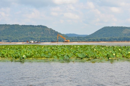
Habitat rehabilitation and enhancement projects are designed to benefit fish and wildlife by restoring lost habitat or protecting existing habitat features. Planned and engineered by the Corps, in partnership with federal and state partners, other organizations and the public, typical habitat projects include restoring/protecting islands, constructing flow control structures or shoreline stabilization features and dredging backwater areas.
Since 1986, the district has completed more than 28 UMRR projects, affecting more than 50,000 acres, or 78 square miles, of river and floodplain habitat. Examples of UMRR projects include the restoration of islands in Pools 5, 7, 8 and 9 of the Mississippi River and the construction of a water level management facility for the Trempealeau National Wildlife Refuge near Trempealeau, Wisconsin. More projects are being planned, designed and constructed. The UMRR has become the most significant effort to restore and protect the natural resource values of the Upper Mississippi River.
Long-term Resource Monitoring
The Upper Midwest Environmental Sciences Center of the U.S. Geological Survey, in partnership with other federal agencies and the five Upper Mississippi River states and funded by the Corps of Engineers, implements the Long-Term Resource Monitoring component of the UMRR. To better understand river processes and conditions, personnel at six field stations collect data on water quality, vegetation, fish, sediment, land use and aquatic insects. The results are analyzed and used to assess the health of the river and forecast future trends. Research studies answer questions about the river’s ecology and future trends. Bathymetric mapping of the river corridor provides useful information for identifying such things as erosion, sediment deposition and transport, and vegetation beds. The Long-Term Resource Monitoring provides a repository for all data collected on the river.